Venezuela Google Maps is a site/tool that offers a wide range of map views (topographic, satellite, street view) and navigation options, with little effort on your part, yet efficiently. If you need to plan a trip to a new place like Venezuela, Google maps are available on desktop, mobile, or tablet. This Google maps and information page is dedicated to Venezuela, South America (13 countries), showing its location, country facts, details about its capital city Caracas, bordering countries like Brazil, Colombia, Guyana, and plenty of other information which may be interesting when you visit this South American state.
Quick links: Google Maps Venezuela, Caracas Google maps, Driving Directions Venezuela, Printable Road Map.
About Venezuela in a nutshell

- Conventional short form of the name: Venezuela
- The conventional long form of the name: Bolivarian Republic of Venezuela
- Local long form: Republica Bolivariana de Venezuela
- Local short form: Venezuela
- Former name(s): State of Venezuela, Republic of Venezuela, United States of Venezuela
- Etymology: native stilt houses built on Lake Maracaibo reminded early explorers Alonso de OJEDA and Amerigo VESPUCCI in 1499 of buildings in Venice, and so they named the region Venezuola, which in Italian means Little Venice.
- The legal system in Venezuela: civil law system based on the Spanish civil code.
- Climate: Tropical. Hot and humid. Uplands are cooler. Orinoco plains are alternately parched or flooded.
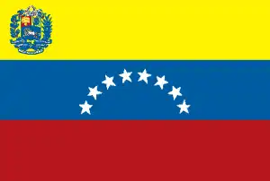
- The national symbol is the troupial (bird). The national colors are yellow, blue, and red.
- Internet TLD: .ve
The land of Venezuela is very diverse: It includes the fragmented, tropical rainforest-covered highlands of the Guiana Mountains, the fan-like rifts of the much younger North Andes rising from tropical desert to rainforest to perpetual ice, the tropical savannahs of the Orinoco Basin squeezed between the two, the lianas, and the tourist paradises of the Caribbean’s sub-Saharan islands: Margarita Island and the coral reefs of Los Roques Islands. The island mountains of the Guyana Archipelago, made up of 1.8 billion-year-old crystalline sandstone, the unique wildlife of tepuis rising to a kilometer and a half from the tropical rainforest, and a series of picturesque waterfalls, including the Canaima National Park, the sixth largest national park on the planet and a World Heritage Site, with the almost one-kilometer-high Angel Falls. Venezuela’s cultural heritage includes the downtown and port of Coro, with more than 600 Spanish and Dutch Baroque colonial buildings, and the modern university city of Caracas, which captures the tropical architecture of the mid-20th century.
Venezuelas Angel Falls is the worlds tallest waterfall, with a total drop of 3210 ft (979 m).
Background
Venezuela was one of three countries that emerged from the collapse of Gran Colombia in 1830 (the others being Ecuador and New Granada, which became Colombia). For most of the first half of the 20th century, Venezuela was ruled by generally benevolent military strongmen who promoted the oil industry and allowed for some social reforms. Democratically elected governments have held sway since 1959, although the re-election of current disputed President Nicolas MADURO in an election boycotted by most opposition parties was widely viewed as fraudulent. Under Hugo CHAVEZ, president from 1999 to 2013, and his hand-picked successor, MADURO, the executive branch has exercised increasingly authoritarian control over other branches of government.
National Assembly President Juan GUAIDO is recognized by more than 50 countries – including the United States – as the interim president. At the same time, MADURO retains control of all other institutions within the country and has the support of security forces. Venezuela is currently authoritarian, with only one democratic institution – the National Assembly – and substantial restrictions on freedoms of expression and the press. The ruling party’s economic policies expanded the state’s role by expropriating significant enterprises, strict currency exchange and price controls that discourage private-sector investment and production, and overdependence on the petroleum industry for revenues. However, Caracas 2019 relaxed some economic controls to mitigate some impacts of the economic crisis driven by a drop in oil production. Current concerns include human rights abuses, rampant violent crime, high inflation, and widespread shortages of essential consumer goods, medicine, and medical supplies.
Geography
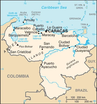
Andes Mountains and the Maracaibo lowlands in the northwest. The Orinoco River system drains central grassy plains. The forested Guiana Highlands in the southeast.

Lying on the southern shores of the Caribbean, Venezuela was the first of Spains colonies to seek independence. Despite significant oil revenues, many Venezuelans still live in poverty.
This state is located in Northern South America, bordering the Caribbean Sea and the North Atlantic Ocean, between Colombia and Guyana, under the coordinates of 8 00 N, 66 00 W, covering an area of 912,050 sq km with a coastline of 2,800 km. Venezuela is almost six times the size of Georgia and slightly more than twice the size of California.
Venezuela has 5,267 km of land boundaries and borders (3 nations): Brazil 2137 km, Colombia 2341 km, and Guyana 789 km.
Andes Mountains and Maracaibo lowlands in the northwest, central plains (llanos), Guiana highlands in the southeast, Pico Bolivar 4,978 m as the highest point of Venezuela, and the Caribbean Sea 0 m as the lowest point, causing a mean elevation of 450 m throughout the country. With a total of 912,050 sq km, Venezuela has 882,050 sq km of land and 30,000 sq km of water surface area.
Major water bodies in the country: Lago de Maracaibo – 13,010 sq km (saltwater lake) while the major rivers are: Negro (shared with Colombia and Brazil) – 2,250 km, Orinoco (shared with Colombia and Guyana) – 2,101 km. The significant watersheds for Venezuela are Atlantic Ocean drainage: Amazon (6,145,186 sq km) and Orinoco (953,675 sq km).
The climate in Venezuela is as follows: Tropical, hot, humid, and more moderate in the highlands.
When you visit Venezuela, the natural hazards shall be considered: Subject to floods, rockslides, mudslides, and periodic droughts.
The following major health-threatening issues shall be considered when visiting Venezuela: degree of risk: high (2020), bacterial diarrhea and hepatitis A, dengue fever, and malaria.
Current environmental issues affecting the Venezuelan people: sewage pollution of Lago de Valencia; oil and urban pollution of Lago de Maracaibo; deforestation; soil degradation; urban and industrial pollution, especially along the Caribbean coast; threat to the rainforest ecosystem from irresponsible mining operations.
Google Maps Venezuela
The capital and other divisions
Capital city: Caracas found under the coordinates 10 29 N, 66 52 W, applying the time zone UTC-4 (1 hour ahead of Washington, DC, during Standard Time), using the following daylight saving time: none.
Caracas has been the capital of Venezuela since 1810, when it was declared the capital. It is the country’s most populous city and economic, cultural, and political center. The city lies on the Caribbean coast at the delta of the Orinoco River in a valley surrounded by mountains. Home to a rich history and culture, it is also known for its stunning natural scenery and surrounding beaches. With many universities and colleges, Caracas is an educational hub attracting students from regions across Venezuela with diverse social events such as Carnival and the Festival of San Diego.
Venezuela became independent on 5 July 1811 (from Spain), and its national holiday was Independence Day on 5 July (1811).
Administrative divisions: 23 states (Estados, singular – Estado), 1 capital district (distrito capital), and 1 federal dependency (dependencia federal); Amazonas, Anzoategui, Apure, Aragua, Barinas, Bolivar, Carabobo, Cojedes, Delta Amacuro, Dependencias Federales (Federal Dependencies), Distrito Capital (Capital District), Falcon, Guarico, La Guaira, Lara, Merida, Miranda, Monagas, Nueva Esparta, Portuguesa, Sucre, Tachira, Trujillo, Yaracuy, Zulia note: the federal dependency consists of 11 federally controlled island groups with a total of 72 individual islands.
People and society
Venezuela is historically a “melting pot” with Europe and Latin American immigrants. The few indigenous Amerindians live in remote areas. Venezuela has one of the most urbanized societies in the region, with most of its population living in the northern cities. The left-wing rhetoric of President Hugo Chávez (1999-2013) raised opposition within Venezuela from urban society and the U.S.
The population in Venezuela is 29,069,153 (July 2021 estimate), with an average of 2.46% (2021 estimate) change. That means Venezuela is the No. 50 in the world’s populated rank list. With an average of 30 years median age (29.4 years for males and 29.4 years for women), Venezuela ranks No. 124 on the globe’s median age list.
The people living in this country are the Venezuelan(s) (noun) or Venezuelan (adjective) and belong mainly to the following ethnic groups: unspecified Spanish, Italian, Portuguese, Arab, German, African, and Indigenous.
They speak Spanish (the official language) and numerous indigenous languages and practice the following religions: nominally Roman Catholic 96%, Protestant 2%, and other 2%.
We can conclude the following about the population in Venezuela: Most of the population is concentrated in the northern and western highlands along an eastern spur at the northern end of the Andes. This area includes the capital of Caracas. In Venezuela, we are talking about 88.3% (2021) of the total population lives in cities, and most of them reside in the following municipalities: 2.946 million, Caracas (capital city), 2.296 million, Maracaibo, 1.935 million, Valencia, 1.227 million, Barquisimeto, 1.216 million, Maracay (2021).
Industry
Oil accounts for 95% of exports, the world’s largest reserves. Coal, gold, and other minerals. Nationalizations are enlarging the inefficient, corruption-prone state sector and deterring foreign investors.
Venezuela remains highly dependent on oil revenues, which account for almost all export earnings and nearly half of the government’s revenue, despite a continued decline in oil production in 2017. Without official statistics, foreign experts estimate that GDP contracted by 12% in 2017, inflation exceeded 2000%, people faced widespread consumer goods and medicine shortages, and the central bank’s international reserves dwindled. In late 2017, Venezuela also entered selective default on some of its sovereign and state oil companies, Petroleos de Venezuela, S.A. (PDVSA) bonds. Domestic production and industry continue to underperform severely, and the Venezuelan government continues to rely on imports to meet its basic food and consumer goods needs., Falling oil prices since 2014 have aggravated Venezuela’s economic crisis. Insufficient access to dollars, price controls, and rigid labor regulations have led some U.S. and multinational firms to reduce or shut down their Venezuelan operations. Market uncertainty and PDVSA’s poor cash flow have slowed investment in the petroleum sector, resulting in a decline in oil production.
Under President Nicolas MADURO, the Venezuelan Government’s response to the economic crisis has increased state control over the economy and blamed the private sector for shortages. MADURO has given authority to produce and distribute essential goods to the military and local socialist party member committees. The Venezuelan government has maintained strict currency controls since 2003. The government has been unable to sustain its mechanisms for distributing dollars to the private sector because it needed to withhold some foreign exchange reserves to make foreign bond payments. As a result of price and currency controls, local industries have struggled to purchase production inputs necessary to maintain their operations or sell goods at a profit on the local market. Expansionary monetary policies and currency controls have created opportunities for arbitrage and corruption and fueled a rapid increase in black market activity.
Venezuela is rich in the following natural resources: Petroleum, natural gas, iron ore, gold, bauxite, other minerals, hydropower, and diamonds.
The main industrial sectors are agricultural products, livestock, raw materials, machinery and equipment, transport equipment, construction materials, medical equipment, pharmaceuticals, chemicals, iron and steel, crude oil, and petroleum products.
The country’s export sectors are particularly strong in crude petroleum, refined petroleum, industrial alcohols, gold, and iron (2019), partnering with these nations: India 34%, China 28%, the United States 12%, Spain 6% (2019). The export trade resulted in $83.401 billion. Note: Data are in current year dollars (2018 estimate). In a global rank of the export, values resulted in Venezuela’s position of 45.
Land use in Venezuela: 52.1% (2018 estimate) forest, 23.4% (2018 estimate) other.
The arable land area is 3.1% (2018 estimate), and the agricultural land is 24.5% (2018 estimate). Land use for permanent crops is 0.8% (2018 estimate), and permanent pasture is 20.6% (2018 estimate). The summed area of the irrigated land is 10,550 sq km (2012).
The main agro-industrial products of Venezuela are sugar cane, maize, milk, rice, plantains, bananas, pineapples, potatoes, beef, and poultry.
The country typically needs to import: refined petroleum, rice, corn, tires, soybean meal, and wheat (2019), partnering with the following nations: China 28%, the United States 22%, Brazil 8%, Spain 6%, Mexico 6% (2019) in a sum value of $18.432 billion (2018 estimate) $18.376 billion (2017 estimate). This sum value on the global ranking list of imports resulted in Venezuela’s 89.
Venezuela Driving Directions
In this post, you learned about Venezuela, Northern South America, bordering the Caribbean Sea, and the North Atlantic Ocean between Colombia and Guyana. We published some basic information about its capital Caracas, and the Venezuelan nation.
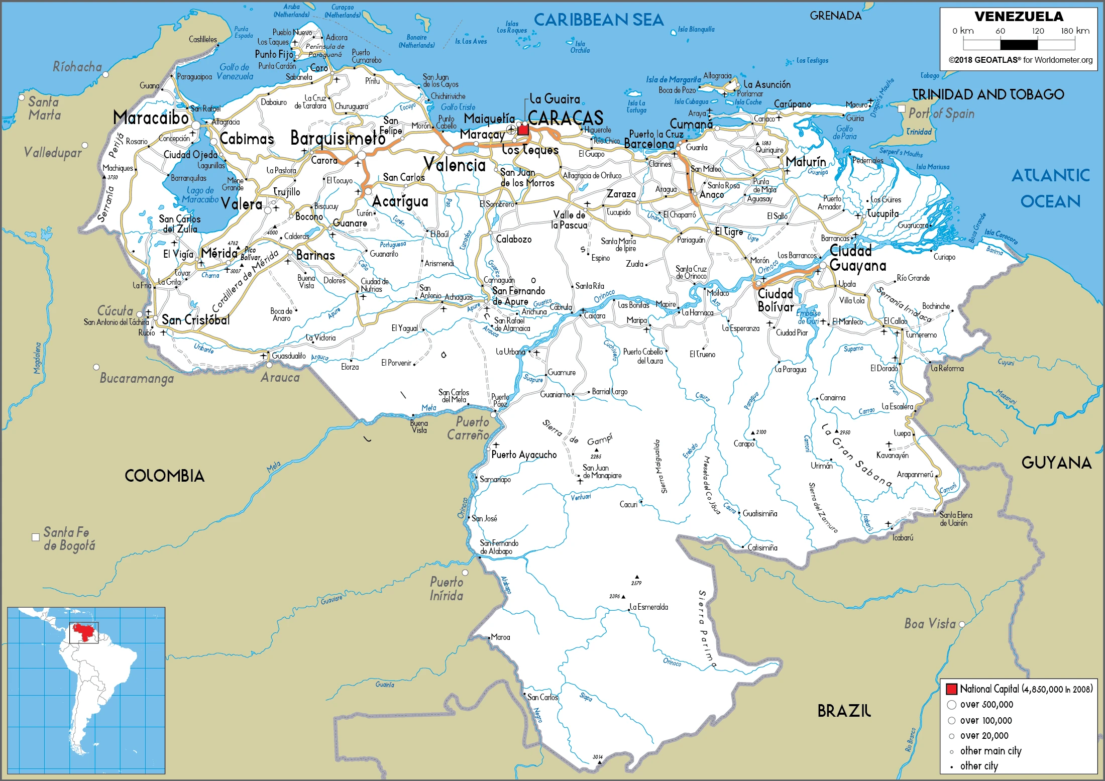
Are you interested in visiting Venezuela and looking for driving directions? Click here to plan your route, or see a printable road map of Venezuela below for an overview of the route network.
Printable map of Venezuela
Did you know about Venezuela?
Did you know that Venezuela is located on the northern coast of South America, bordered by Colombia, Guyana, and Brazil? Venezuela is famous for its diverse landscapes, including the Andes Mountains, the Amazon rainforest, and the Caribbean coastline. The country is also rich in natural resources, such as petroleum, gold, iron ore, and diamonds.
In terms of culture, Venezuela is renowned for its vibrant music and dance scene, with genres such as salsa and merengue being popular throughout the country. The country is also home to several UNESCO World Heritage sites, including the historic city of Coro and the Los Roques Archipelago.
In recent years, Venezuela has faced numerous political and economic challenges, including hyperinflation, widespread food and medicine shortages, and a large-scale humanitarian crisis. Despite these difficulties, the people of Venezuela continue to demonstrate resilience and maintain their rich cultural heritage.
Did you know that Venezuela has an annual income of $1,077? In Venezuela, the minimum wage is worth less than a dollar per day. This is why many Venezuelans leave their home country in search of better opportunities.
Venezuela is the home of the world’s cheapest gas. Only about $0.01 a gallon! Surprisingly, Venezuela isn’t a country full of poor people. Instead, it has the wealthiest local population in all of Latin America.
After virtually visiting Venezuela, you may also be interested in the neighboring countries: Brazil, Colombia, and Guyana.
If you liked our Google map and Venezuela information page,
please share it with others or save the link https://www.drivingdirections.net in your bookmarks.

